|
Article by
Peter
Bailey
(An
introduction to some of the alternative solutions currently available. We hope
to follow with more detailed independent tests of some of the software and
hardware)
Introduction
Learning to fly is clearly one
of the most demanding and enjoyable projects, with the normal objective of
achieving a Private Pilots Licence (PPL).
However most flying schools
operate quite elderly aircraft without in-built GPS systems and PPL navigation
training does not include GPS, nor is it encouraged as a "reliable"
primary system.
Training for VFR (visual flying) and IFR
(instrument flying) relies on paper maps and runway layouts, plastic "flight
computers" (to allow for wind direction and speed
effects), magnetic and gyro compass, air speed calculation, timing and use of
the various type of radio beacons depending upon the sophistication of the
on-board instrumentation.
Modern "professional"
in-built GPS systems, usually combine detailed and
zoomable aeronautical map, and airport diagrams as well as a comprehensive
database. This equipment, when used as the primary navigation aid can
revolutionize the way you fly and make life easier for navigation, flight
regulations and restrictions and radio communications.
Category 1 Equipment -
(Memory-Map
and Aeroplanner software)
For "fly
aways" or just the experience of using GPS in the air
the variety of portable equipment can provide an attractive option although it
is normally considered as a SECONDARY navigation aid.
For those who already possess a Pocket PC and possibly a GPS
antenna there is a relatively low entry cost. (e.g. about Ł50 for a CAA 1/500K
U.K. map.) which allows the facility of waypoint and route planning PLUS live
tracking of actual position with height, speed and position data as a bonus.
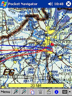
Memory-Map Pocket Navigator
Category 2
Equipment - (Winpilot,
Anywheremap, gonavgps etc.)
More advanced PDA sytems can use the same hardware but with
screens and data comparable to the pro. in-built kit. If you are regularly
flying then the typical cost of $200 – $400 plus upgrade fees could well be
worthwhile.
Category 3
Equipment - (Garmin
GPSMAP196)
To start from scratch the excellent purpose
built Garmin range becomes a realistic option. The GPSMAP 196 is a well
specified map and data device (ca. $1000) and the colour screen 295 (ca $1500).
A separate antenna would be a preferred option.
Category 4 Equipment - (Pocket
FlightPlan)
There are also various "utilities" for the Pocket PC which can be
used as flight calculators for ca $10, replacing the beloved "plastic disc
computers"
Other essentials to be
considered will include holding and mounting devices. The screen positioning
must allow for easy viewing and touch control whereas the antenna must have a
clear sky view. Panel mounts as well as "knee pads"
are some of the choices. For longer trips, and
to activate some antenna a power source will be needed. If
a "car accessory plug" is
available this will be fine but, if not, some battery pack must be considered.
The last thing you need when flying is to become tangled in
the GPS wiring, therefore plenty of consideration is needed in the positioning
of the components and their connection.
Bluetooth components should be a practical solution although I have not seen any
definitive acceptance of yet more radio waves in the cockpit!!!
Here is a selection of kit available:-
Category 1
|
Memory Map with CAA Maps |
These come as regional packages at scales of 1/250k and
1/500k together with the invaluable airport diagrams. The maps are clear
and well marked but for in flight use the 1/500k is most practical. No
Com. frequency or other data provided.
|
| Aeroplanner |
The Aeroplanner website can provide detailed
information on most European airfields with frequencies etc., ideal for
pre-flight planning. The downloadable maps (ca$7.50) are only 1/1m scale
and have a bluish haze. I have found that my iPAQ
3850 is a bit lacking in screen clarity with the Aeroplanner maps and
would love to upgrade to the newer, high contrast, PDA’s. |
Category 2
|
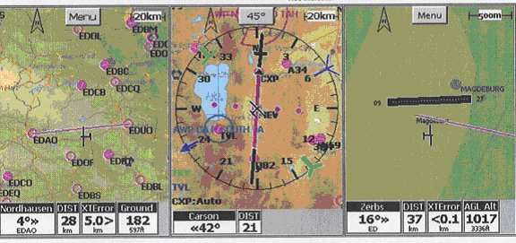
Anywhere Map v1.35
|
Anywhere Map
v1.35 offers a comprehensive set of map and flying aid displays together
with airport diagrams. Complete packages with iPAQ
3950 are offered at $1,295 but I have not yet been able to find the cost
of software only packages nor of European mapping and data.
Looks very comprehensive and worth a serious test
flight.
http://www.anywheremap.com
|
|
NavGPS Pro |
NavGPS Pro
is certainly a contender with worldwide vector based mapping, excellent
displays and a single user price of only $174. Subsequent 13 issues of
updates at 28 day intervals cost $80.
http://www.gonavgps.com
|
|
Winpilot |
Winpilot is a very flyer friendly package with UK and
French maps available. Displays are clear and comprehensive but cost is
stated as $299
http://www.winpilot.com
|
|
Efis Ce |
Navtech Software
provide Efis Ce as a good mapping system with a facility for scanning in
your own maps at Ł70. Their PPCe6b is an
approach to provide comprehensive data but no maps.
http://www.palmplan.flyer.co.uk/efis
|
|
Teletype Aviation |
Teletype offer a very comprehensive aeronautical
package which, for Europe, also includes street maps for a price of $224.
From the spec. it would appear that maps can be stored on PC with world
wide aeronautical data to be selectively transferred to the Pocket
PC.
http://www.teletype.com
|
Category 3
|
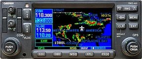
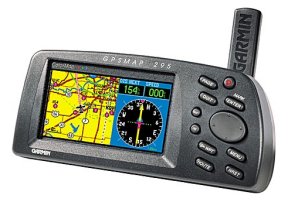
Garmin GPSMAP 196 |
Here Garmin appear to
lead the field with comprehensive, aeronautical specific equipment.
The GPSMAP 196 provides a B/W package for $1049 with
full regional data and a battery life of 4-16 hrs.
The colour GPSMAP 295 has
similar capabilities but 6xAA batteries only last for 2.5hrs. Garmin do
provide a good range of accessories including battery packs and external
antenna. Some pilots use both ‘Garmin’ and
PocketPC together with the ‘Garmin’ providing the gps signal.
http://www.garmin.com
|
Category 4
Quite a few small developers
provide simple software packages for basic calculations; such as wind effect and
take off performance.
|
Deloach Flight Calc |
Deloach have a flight calculator at $10, a holding
pattern calculator at $8 and a ‘takeoff performance calculator at $10.
http://www.deloach.com/avsoft.htm
|
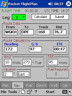
Personally I use a versatile
flight planning calculator which does wind, load and fuel calculations from
Pocket FlightPlan at Ł13.36
and find it quite useful, fully replacing the traditional plastic disk flight
computer.
Other software, obtainable from
Handango, includes:- Embedded Flight
Computer, Aviators Navigation Calculator, Flight Calc, Flight Planner 2001, and
Aerocalc.
These comments and descriptions
are by no means comprehensive and do not include very precise evaluations of
specific products. However they should provide some insight on cost, benefits
and choice.
For the future, with the fast
developments in Street Routing Software
perhaps we can look forward to voice instructions and
prompts as well as 3D "heads up"
displays soon.
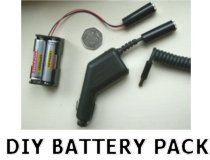
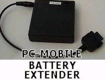
Mobile Battery Sources
Most people don't realise, but most aeroplane
dashboards are similar to car ones, so it's quite easy to use an In-Car GPS
Receiver. However many older planes do not necessarily have an accessory
socket that can be used, so without power you have no way of powering the GPS
Receiver or a Pocket PC. What you can do is create or purchase differenet
battery chargers that should help supply power. Check out the following
reviews that may help to power the receiver and charge the Pocket PC, or just
simply allow charging when you don't have any power.
|