
Google Earth Launched
Date: Wednesday, June 29 @ 20:25:48 UTC
Topic:
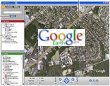 First there was Google Maps and now there is Google Earth.
This superb application allows you to view satellite images of anywhere on our planet with some areas in amazing detail.
First there was Google Maps and now there is Google Earth.
This superb application allows you to view satellite images of anywhere on our planet with some areas in amazing detail.
All you require is a broadband connection to make the most of this, it is free to download in its basic form but is also available in a Plus version which adds amongst other things GPS support (although you would still require a broadband link to access the maps! and a PRO version which adds data import and higher resolution prints. In all versions the feature list includes:
Fly from space to your home area.
Type in an address and zoom right in.
Search for schools, parks, restaurants, and hotels.
Get driving directions.
Tilt and rotate the view to see 3D terrain and buildings.
Because it is still in Beta, access to the download is occasionally restricted but keep trying and you will get through!
Click here to visit the Google Earth homepage...
Click here to discuss...
|
|