|
|
 |
 |
 |
 |
| Navman launch new iCN SatNav systems |
30th
March 2006 |
|
Article by Tim Buxton and Mike Barrett
Last Thursday PocketGPSWorld,com was invited to a special Navman Press briefing at the exclusive Morton's in Berkeley Square in London. The reason for this low key session was to give us a preview of the new Navman iCN range of SatNav devices.
It is becoming the norm in the GPS industry to put on big Press extravaganzas, inviting all the press and industry to the launch. It was therefore refreshing to miss the hustle bustle and fighting for interviews, and have one to one discussions with the guys that count. We were fortunate to talk to Navman President Prash Vadgama, and the European Marketing Manager Martin Capel-Smith. We were allocated a 40 minute slot for the briefing, but tacticlly we went for the last session of the day at 16:00. Yep you guessed it: we didn't get away until 19:30, a very good 40 minutes. In this time we had a good chance not only to give the Navman guys a good grilling, but to play with the new toys as well...
Unfortunately despite the pocket sized SatNav systems, they were all returned to Navman before we left.
|   |
Summary
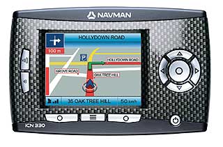
Navman have launched four new devices and a revolutionary service. The new devices are: the iCN330; the iCN530; and a new top of the range iCN720 and iCN750. The new systems feature the latest SiRF GPS chipsets, and the iCN330 also has interchangeable facias.
The new service is NavPix™. Navman NavPix™ is a new service that uses image POIs. The concept is that you capture an image, and then navigate to it. So how do you capture the image? Simple, the new iCN7xx SatNav systems have an integrated camera. See below for more details. |
 |
The Navman iCN330
We didn’t get to see much of the 330 but from what we understand, it is similar to the 320 except that it has full moving maps, whereas the 320 only shows maps where instructions are involved.
It also has a ‘progress bar’ in which a red bar rises up the lefthand side of the screen as you get nearer to the next instruction. Other than that it is pretty much identical to the 320.
Although we didnt get to see it the press information shows different interchangeable fascias for the iCN330. These range from the standard silver through to carbon and woodgrain effect. This allows you to personalise your system to match your car.
|
 |
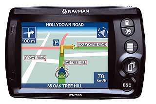
The Navman iCN530
The Navman iCN530 shares the same 3.5” touchscreen as the previous 5xx series devices and is roughly the same size as the 510/520, and at only 20mm thick it will easily slip into a shirt pocket. Unfortunately they insisted we removed it from our pockets before we left...
The software menu system on this model is of similar design to SmartST V3 and 2005 but there are new buttons brought in from the iCN550 which will navigate you to the nearest Fuel Station or Carpark. The other three buttons are Menu, Page (forwards) and Escape (backwards).
Everything else, such as zoom and keyboard entry, is done via the touchscreen whereas with the 510/520 you could choose screen or fascia buttons. One new option we noticed was that there was an ‘Auto’ setting with the ‘Day’ and ‘Night’ options. We think that this is a user-defined setting though, as opposed to being fully automatic using Sunrise and Sunset times.
Another new feature is the GPS chipset, which is 2nd generation SiRFStarIII. This should improve satellite reception and, indeed, situated on the second floor of Morton’s about 12 feet from the nearest window, we managed to get a fix.
And there’s still more. A TMC module is available as an optional extra (use is limited to UK, Germany and France). Like the one for the iCN550, this will cost an extra £100 or so but that price includes a one-off licence fee. This allows the user to specify whether they want a warning or to be automatically rerouted in order to minimise delays. The module attaches to the screenmount and at first glance we didn’t realise that it wasn’t a one-piece unit.
|

|
The region-specific maps on this unit are stored in NAND flash memory, meaning whatever region you buy the device in, those maps will be in the NAND flash, whose size will vary from region to region (UK will be 256Mb). Finally, the UK maps include full 7 digit postcode navigation, a feature which has been long-requested, at least on this site. We had a quick look and the data itself appears to be accurate with the few postcodes we know off by heart, and it narrows down the possible list with each character.
The maps for the other regions come on CD and can either be added to the NAND memory or stored on an SD or MMC card, for which a slot is provided. We understand that those maps will not require any extra payment for their use. Also in the box will be a car charger, mains charger and remote control, along with the carmount.
|
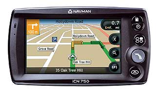
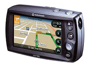
The Navman iCN720 and iCN750
There are currently two units in the the new Navman iCN7xx range: these being the iCN720 and the iCN750.
Interestingly while most of the new SatNav devices feature integration of mobile phone technologies and multimedia functionality Navman have focused their attention firmly on the core SatNav technologies.
These are new units from the ground up, and feature 4” WQVGA (480x272 pixels) LCD widescreen displays. Like the iCN530, fascia buttons are limited to the same five, and most of the controls are adjusted using icons on the screen. Naturally, they are bigger brothers to the iCN530 and also use the 2nd Generation SiRFStarIII chipsets. They can accept the same TMC module.
The main difference between iCN720 and iCN720 is that the lower spec iCN720 has region specific maps only, stored on a 512Mb internal CF card, whereas the iCN750 has the 18 country mapset stored on its internal 4Gb hard drive. They both have an SD/MMC slot, just in case more storage space is required.
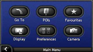
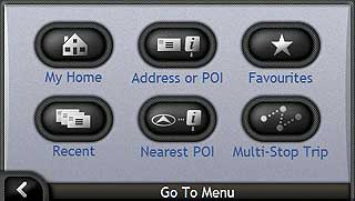
Unlike the iCN530, the software GUI is new from the ground up. The ‘List’ menu is replaced by buttons to take advantage of the widescreen. It makes full use of the enhanced screen size with super new graphics and mapping display.
Standard 7 digit postcode data is supplied and you also get enhanced navigation instructions. This enhancement, whilst not Text To Speech, gives Motorway Junctions and road numbers in the instruction.
For instance, I was instructed to ‘Take the exit at junction 10 and take the first exit onto the A Two Six Four’. We now get the countdown in miles and yards, too, after having miles and feet in previous versions.
Little things like this perhaps show that Navman are listening to the feedback given not only directly, but also on sites such as PocketGPSWorld.com.
On the iCN7xx series, the optional remote control is now an RF unit which means that a direct line of sight (or ‘bouncing’ the signal off a suitable object) is no longer required. Indeed, you can attach the remote to your steering wheel, alleviating the need to remove a hand from it in order to operate the remote.
The windscreen mount for these units is a monster and is an easy attach/easy detach system. In these days of more and more thefts of satnav devices being reported, this shows a bit of forethought.
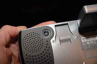
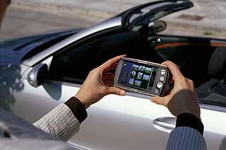
But the piece de resistance for the iCN7xx units is the built-in 1.3Mpixel camera. How does this fit in with then concept of focusing on the core SatNav functionalities?
Well this is something that a lot of people (including myself) have been playing around with for a while now... And created NavPix™.
|
|
| Navman's new service NavPix™
Take a GPS, add a camera, take a picture, then record the position and voila we have what is known as a geo-referrenced photo which can identify exactly where a picture was taken.
Navman have very cleverly added functionality to the new iCN7xx hardware and software to allow you to navigate to one of these picture POIs. They have named this new feature NavPix™.
So what is the idea behind this? When you find somewhere, maybe by chance, that you want to go back to, or you just think it is such a find that you want to share it, then you take a picture using your iCN7xx.
|
|
As long as you have a GPS fix, the latitude and longitude of your location will be embedded into the picture file. This will pinpoint the location that the image was created allowing you or someone who has your picture to navigate to.
There will be an area on Navman’s website where you can upload your NavPix to. Similarly, you can download other NavPix which have been uploaded by others.
How many times have you heard of some great view, monument or feature but have never been able to find it? With its NavPix on your unit, you’d know exactly what you were looking for. |
 |
The potential for this is endless. PocketGPSWorld.com is already talking to Navman with a view to creating a database of NavPix™ POIs.
You can imagine creating tour guides where you can be directed to the exact viewpoint. Plug these into itineraries and you can have compact city guides.
Want to let your friends know what your house looks like as they come for your dinner party? No problem stand outside snap a quick picture and share the NavPix POI with them.
Seen the special something you want? Take a NavPix and drop a less than subtle hint to your partner.
|
 |
Navman Press Releases
The following 3 items are the official Navman Press releases for the new products.
|
Navman Launches the Perfect, Portable Navigation Package - The New iCN530
LONDON, March 30, 2006
Satellite navigation pioneer Navman launches the new iCN530, the perfect, portable navigation package. Sleek and pocket-sized, the new iCN530 measures just 22 millimetres in depth and weighs less than 200 grams, making the iCN530 one of the lightest and most portable navigation models ever. The iCN530 also features an integrated SiRF Star III GPS antenna and a non-reflective 3.5 QVGA LCD touch-screen.
The iCN530 is packed with advanced features: extended voice guidance which now includes junction and road numbers; clearer map display and colour choice; additional 3D next-turn map arrows; and detailed trip-meter report. Furthermore, the iCN530 offers unique one-touch fuel and park buttons to quickly and safely locate the nearest petrol stations and parking places.
A new and simplified car mount design also allows quickrelease and safe storage of the iCN530. To escape traffic, the iCN530 also offers subscription-free, live traffic information via an optional traffic pack first launched by
Navman in 2005.
Escape Traffic
The innovative traffic pack makes the iCN530 the definitive driving companion. Attach the pack and the iCN530 receives live TMC traffic updates. Updates are then displayed as icons on the map to provide all the information you need for the road ahead. You can therefore easily plan your trip, while also choosing between automatic or manual re-routing to avoid congested areas.
The plug and play pack fits neatly and discreetly into the back of the iCN530 cradle and includes subscription-free traffic information for the UK, France and Germany, with no need for additional equipment and no hidden data costs.
Ultimate Performance
The iCN530 comes equipped with the very latest GPS technology in second generation SiRF Star III. It pinpoints your location even faster and improves reception in environments where there is a weak signal, such as areas surrounded by high buildings or dense foliage.
Ultimate performance doesn t just mean superb GPS though; simplicity and ease-of-use are also key contributors to the iCN530 s performance. Designed to work straight out of the box, the iCN530 offers all the great features associated with the current Navman iCN range including back-on-track technology, 3D-map view and turn-by-turn voice instructions.
In fact, navigation couldn t be easier: By simply inputting a destination on the colour touch screen, the iCN530 quickly plans the best route door-to-door. There is a wide range of ways to enter a destination, including by area, town, specific street, junction or point of Interest. The iCN530 even supports full UK postcodes, for quick and simple input to precise locations.
UK and Ireland maps packed with the latest TeleAtlas data are standard on the iCN 530, while the supplied CD provides additional street-level maps for 17 European countries.
Advanced map imagery gives a superb impression of surroundings on screen, including land contours, parks and forests and a choice of full 3D moving maps, plus a 2D mini-map screen and route summary.
Also included with the iCN530 are a sleek lightweight remote control, car charger and main power adaptor.
The Perfect Portable Package
Prash Vadgama, president of Navman s Consumer Navigation Group, said, We are constantly looking at ways to push the boundaries of satellite navigation through innovative product development. Navman was the first GPS provider to offer subscription-free live traffic, and the traffic pack with the iCN530 is a good example of how, once again, we are
driving portable navigation to the next level. We have already experienced great success with traffic information through our high-end iCN550 and we are excited to bring an affordable device to the market that offers the fantastic additional value of real-time traffic information.
The iCN530 represents Navman's continued drive to create great user experiences by focusing on the important things, Prash explained. Portable design is important to users for both convenience and security reasons. Our innovative one-touch fuel and park buttons help users access important last-mile information both quickly and safely. Also, our advanced, new features such as extended voice guidance and live traffic deliver a richer and more beneficial experience. In short, the new iCN530 s advanced features add up to provide the perfect, portable iCN package.
Availability
Available starting in April 2006 from leading retailers and e-tailers, the iCN530 will retail for £299 Inc VAT. The traffic pack is available separately for approximately £100 Inc VAT. |
|
Navman s New iCN720 and iCN750 to Provide World-First,
Portable, In-car Navigation System Using NavPix
LONDON, March 30, 2006
Satellite navigation pioneer Navman announced today that it
has launched the new iCN720 and iCN750, two innovative portable navigation products
featuring NavPix a breakthrough technology which offers a unique and intuitive way to
navigate to a destination using just images. Available in Europe starting in May 2006, both
systems offer the very latest high-definition, 4-inch widescreens and brand-new navigation
software, together with the very latest GPS technology and live traffic information.
As simple as: Picture, Touch, Go
Images are an obvious and unmistakeable way to identify a destination, says Prash
Vadgama, president of Navman's Consumer Navigation Group. For example, if we wanted
to enter the Eiffel Tower as a destination within a current navigation device, how many of
us would know the actual address? Not many, but we all know what it looks like. With
NavPix , you simply view the NavPix images on your Navman, touch the NavPix you
want to select, and go.
Click, Share, Download, Explore
You can use the built-in camera on the iCN700 series to take a NavPix image of
something that inspires or interests you, says Prash. It might be a location you've
stumbled upon by chance and want to return to. It could be a great restaurant, a scenic
view or an amazing building or maybe something relevant to your professional life, such
as a location for a photo shoot, a property for sale or a scene you need to record .
Once created, NavPix images can be uploaded and stored within a personalised, online
album that can be created on the Navman website at www.navman.com. The website will
also have NavPix images of famous landmarks and interesting places to download, as
well as online tools to create NavPix
images from any digital picture such as jpegs, by
automatically assigning the complete longitude and latitude information to the image. When you've taken and uploaded your own NavPix images, you can share them with other
NavPix creators and users from the Navman global community.
NavPix : Picture Yourself There
We are proud to be launching a world-first technology with NavPix , says Prash. We
strongly believe that it will become the de facto standard for navigation in the future. This is
the beginning of a pioneering and exciting new process.
Wide-screen navigation
Both the iCN720 and iCN750 boast the latest 4-inch, high-resolution screen with 70 percent
more pixels than most products available on the market today. This high-quality display
offers a crystal-clear 3D view of the route. Navman has developed a new software interface
to accompany this widescreen format, with user-friendly touch screen and soft keys to
easily access navigation functions. Getting from point A to point B has never been so
simple.
Most satellite navigation products on the market today offer QVGA screens (320x240 pixels) while the iCN720 and iCN750 are equipped with the world s first WQVGA high resolution screen (480x272 pixels).
Second-generation SiRF Star III The Latest GPS technology
The new iCN720 and iCN750 feature the very latest GPS technology: the second generation
SiRF Star III. The reception is significantly improved in environments with a
weak signal such as areas surrounded by high buildings or dense foliage. This new GPS
technology also offers lower power consumption therefore providing longer battery life.
All new navigation software
The iCN700 series features brand-new navigation software with many added, advanced
features to enhance the user experience. Advanced motorway guidance not only tells you
which junction to take, but also what road to enter next. The new, built-in trip computer
gives you full details of your journey including distance travelled, time taken, average
speed, maximum speed, and even time spent stationary.
Smart navigation: Escape traffic jams
The optional traffic pack makes the Navman iCN 700 series the ultimate tool for all
motorists. The iCN720 and iCN750 display live traffic information as icons on the map and
provide you with all the information you need about the road ahead. Users can easily plan
their trip, view incidents and re-route to avoid problems. The traffic pack is plug-and-play
and includes a free, lifetime traffic subscription for the UK, France and Germany, with no
need for additional equipment and no hidden data costs.
Intelligent safety camera data
Navman iCN700 series devices also offers up-to-date safety camera warnings through a
database which can be downloaded from www.navman.com. Users can activate an audio
warning of the legal speed limit when approaching a speed camera.
Additional Features
Featuring two dedicated hardware buttons with clear icons, the iCN720 and
iCN750 are the only navigation systems that allow you to find nearby fuel stations
and parking areas at the touch of a button.
In the United Kingdom, the full postcode search lets you find your destination
quickly and easily.
An optional RF remote control can be attached to your steering wheel, enabling
you to operate the unit easily and safely. With RF technology, the remote is easier
to use as there is no need to point the remote control directly at the iCN.
The iCN720 features maps of the UK and Ireland while the iCN750 has detailed
maps of 17 Western European countries pre-installed on its built-in hard drive.
New, easy release car suction mount makes it simple and easy to install and
remove for secure and quick storage.
Price and availability
The iCN720 and iCN750 models will be available from leading retailers and e-tailers
starting in May 2006. Both units come with a car suction mount, cigarette lighter adaptor,
carry case, USB cable and main power adaptor. The iCN720 will retail for £399 and the
iCN750 for £549 inc. VAT. The traffic pack is available separately for approximately £100
inc. VAT.
|
|
Navman Introduces the World s First Image-based Navigation
System Meet NavPix and Change the Way You Navigate
Forever
LONDON, March 30, 2006
Satellite navigation pioneer Navman is introducing NavPix , a breakthrough technology which offers a unique and intuitive way to navigate to a destination using just images. NavPix goes beyond just simplifying navigation: it introduces a whole new image-based approach to navigation that is easy to use and can be used anywhere, both in and out of the car. NavPix will initially be available on two new, state-of-the-art Navman portable navigation devices the iCN720 and iCN750,available in Europe from May 2006.
As simple as: Picture, Touch, Go.
Images are an obvious and unmistakeable way to identify a destination, says Prash
Vadgama, president of Navman's Consumer Navigation Group. For example, if we wanted
to enter the Eiffel Tower as a destination within a current navigation device, how many of
us would know the actual address ? Not many, but we all know what it looks like. With
NavPix , you simply view the NavPix images on your Navman, touch the NavPix you
want to select, and go. Your Navman device will automatically calculate the best route to
your destination without entering any complicated, alphanumeric addresses.
Each NavPix
image has the exact geographical location of where that picture was taken
embedded in the image data. You then use that image as an alternative way to choose and
set your destination in the Navman iCN700 series, adds Prash.
Click, Share, Download, Explore.
You can use the built-in camera on the iCN700 series to take a NavPix image of
something that inspires or interests you, says Prash. It might be a location you ve
stumbled upon by chance and want to return to. It could be a great restaurant, a scenic
view or an amazing building or maybe something relevant to your professional life, such
as a location for a photo shoot, a property for sale or a scene you need to record .
We tend to remember images better than we remember addresses. A NavPix image is
therefore a much clearer way to find a location because it combines the easy identification
of a location with accurate and precise geographical data. Take a NavPix image and your
Navman device automatically assigns the longitude and latitude of the location, together
with complete address and postcode information. You ll then always be able to navigate to
that exact spot again by using the NavPix to set the destination on your Navman.
Once created, NavPix images can be uploaded and stored within a personalised, on-line
album that can be created on the Navman website at www.navman.com. The website will
also have NavPix images of famous landmarks and interesting places to download, as
well as on-line tools to create NavPix images from an address with a digital picture such
as jpegs, by automatically assigning the complete longitude and latitude information to the
image to create a new NavPix .
This is just the beginning of what you will be able to do with NavPix , says Prash.
When you ve taken and uploaded your own NavPix , you can share them with other
NavPix creators and users from the Navman global community. Sharing NavPix
images with friends or the Navman community will be easy and will open a world of
opportunities for different users across the globe.
NavPix : Picture Yourself There.
Prash says: The possibilities of NavPix are almost endless, for both leisure and
professional users. This innovative technology marks a completely new approach to
satellite navigation, one which will change the way people navigate in the future. In
essence, NavPix is the beginning of a pioneering and exciting new process.
|
|
|
|
 |
 |
 |
 |
|
|


