
Augmented Reality Navigation - Wikitude Drive
Date: Tuesday, September 01 @ 15:56:04 UTC
Topic:
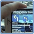 The guys over at Mobilizy have come up with a novel Augmented Reality solution. Using the Android and iPhone platforms they have developed a navigation application which uses GPS, a camera and the built-in compass and tilt sensors to overlay road signs and turn directions on the real world view. The guys over at Mobilizy have come up with a novel Augmented Reality solution. Using the Android and iPhone platforms they have developed a navigation application which uses GPS, a camera and the built-in compass and tilt sensors to overlay road signs and turn directions on the real world view.
Whilst the basic concept isn't new, Blaupunkt have had their TravelPilot 700 PND that uses a camera to offer a similar function, this goes one step further by using the compass and tilt sensor to accurately map the signage and turn directions as you move the phone around.
Described as 'launching for Android and iPhone soon', Wikitude Drive offers map-less navigation with integrated voice commands. Data is downloaded over the air allowing navigation in supported countries world-wide. POI support is mentioned in the features list as is peer to peer and social navigation - whatever that is!
A picture paints a thousand words so take a look at the YouTUBE video which demonstrates it on Mobilizy's website here.
Click here to read more...
Click here to discuss...
|
|