|
 Review by
Peter Bailey Review by
Peter Bailey
Price Ł1000 / $1350
Introduction
 This
isn't a full out review on the Garmin GPSMap295, but a practical evaluation from
a pilots point of view. This
isn't a full out review on the Garmin GPSMap295, but a practical evaluation from
a pilots point of view.
This dedicated colour map
aviation specific device is considered by some as being the ‘standard’ portable
colour screen GPS system for VFR flying.
These notes outline the key features and
performance characteristics and do not attempt to be an instruction manual nor a
review. For those interested in that sort of detail it is freely available
on the Garmin website.
First impressions
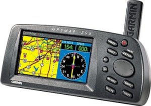
The Garmin GPSMap295 is a solid piece of kit, measuring 3.2” High by 6.8” Wide,
2.6” Deep and weighing about 600gms with batteries.
The unit tested was set up with European mapping
and full database of airports, VOR’s etc and was tested powered with 6 AA
alkaline batteries (lasting for approximately 4 hours) and an external antenna.
A wide range of batteries, cables and mounts are available and the Jeppesen
database can be renewed at $35 for a single update or $295 dollars for 13
updates at 28 day intervals.
Initially it takes some time to get used to the
various button pressing sequences, as there is no touch screen facility. In my
case, unusually ,I had to make regular reference to the explicit manual.
Once past the beginners stage the brilliant screen and logical route planning
reinforced the fact that this is a first class, well thought out navigation aid.
Simulator mode
As the
Garmin doesn't support the downloading of screen shots per se as we normally do
with a PDA, I must apologise for the photographed screen images as they do NOT
do justice to the bright and clearly displayed maps and data.)
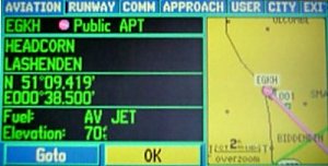
I started with the call sign of my home airport (EGKH-Headcorn) and was able to
call up a screen containing relevant data and runway diagram/map position.
This required a bit of manipulation of the rocker keypad to insert the relevant
alphanumeric symbols.
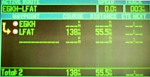
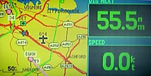
EGKH was inserted as starting point and LFAT (Le Touquet) as destination in the
route planning stage with an immediate course readout (138deg.,55.5nm)
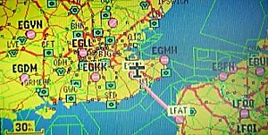
Pressing the PAGE button, called up the map with
the route track already in place, fully zoom able from Europe down to Kent.
With this data held in memory it is a simple
matter to transfer to live mode and have a moving map display of position
together with a selection of navigation information included in the display,
customised to your own preferences. (e.g. distance to next waypoint, ground
speed etc.)
In flight experience
The most significant benefit of the GPSMAP 295 is the screen display. In terms
of contrast, clarity, backlight and lack of ‘glare’ in cockpit conditions it out
performs today’s PDA’s
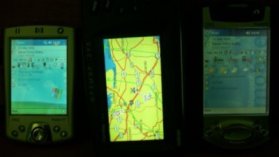
If you
look at the photo below, on the left is iPAQ
2210, centre is Garmin GPSMap295 and right most is the iPAQ 3850.
From my own researches it is the moving map feature which most amateur pilots
appreciate when using portable GPS systems. The GPSMap295 maps have all the essential
aeronautic features including airports and beacons plus traffic restriction and
controlled zones, 2 button zooming (OUT/IN) also allows even the solo pilot to
see exactly where he is.
I am still concerned about a solo pilot doing a lot of button pressing when
flying and, personally would leave any more complex in flight adjustments on the
Garmin GPSMap295 to the co-pilot, acting under the pilots instructions.
With good pre-planning some alternative routes could be instantly available or
by pressing the NRST, (nearest), button a list of nearest airports is available
for in-flight re-routing.
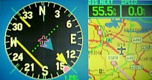
For those who prefer a Horizontal Position Indicator (HPI) a further screen is
available at a touch of the PAGE button.
For our test trip from
Headcorn to Lille with the antenna positioned by the windscreen and the Garmin
on the co-pilots lap the mapping position was absolutely reliable.
Further features
The Garmin GPSMap295 really can be custom setup to meet individual preferences
although the default settings will meet most needs. Map contents and
detail as well as your own waypoints are easy to set up.
As well as nearest airport or waypoint listings a favourite listing is an
excellent feature which allows pre-flight selections to be quickly found if some
re-routing becomes essential.
There is also a useful airport approach feature with diagrams to the specified
runway.
Land mode was not fully evaluated but uses a different pointer and lines
up with the nearest road. The mapping is down to street level and includes
an address search facility and a POI listing of hotels, service stations,
shopping and more.
Below is a brief preview of the main screens visible in sequence when pressing
the PAGE button.

Summary
The Garmin GPSMAP 295 is an excellent, professional, portable GPS navigation
device.
It is expensive to buy and maintain but will appeal to keen amateurs who want a
‘stand alone’ system with full support and excellent colour screen visibility.
There will be an on-going debate about button pressing vs screen touching
but the Garmin GPSMap295 is capable of simple and safe operation by a solo pilot or complex
navigation with the aid of a co-pilot.
|


