|
|
 |
 |
 |
 |
The PocketGPSWorld CeBIT wrap-up
|
Date 12th March 2008
|
| Article by Mike Barrett and Maft Morley | |
CeBIT 2008: Hannover Germany where the World showcases the latest in Digital Technology
|
|
Last week saw the start of CeBIT 2008, billed as "the world's largest trade fair showcasing digital IT and telecommunications solutions for home and work environments".
Last year the show was a little disappointing with the main interest being provided by NavNGo with iGO v8 and a number of low profile stands and an absence of TomTom consumer products. This year was very different. The big stands were back, GPS was in a new and bigger hall. All the main players were there with the exception of Destinator, and it was like a fresh breath had been put back into the show.
We had plenty of new product announcements, from TomTom and Garmin through to Mio-Navman. Looking around the stands the big news once again was NavNGO. iGO 8 software seemed to be the navigation engine for a lot of new devices, including a fully functional "proof of concept" on an iPhone and iPod Touch (check below for video links). The big news though was the split between Mio and NavNGo with Mio now installing the Navman software. Surprisingly the split has been initiated by NavNGo rather than Mio-Navman.
If I had any doubts about the viability of CeBIT as one of the World's foremost tradeshows these were dispelled last week. CeBIT is well and truely on the World map... (sorry for that).
Click here to comment.
|
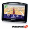
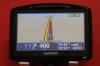
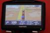
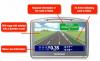
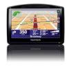
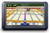
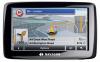
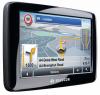
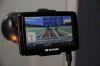
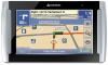
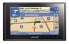
TomTom announce new GO 930, 730 and 530 at CeBIT
TomTom announced a new range of devices at CeBIT today the new GO x30 series. In Europe there will be a TomTom GO 930, GO 730 and TomTom 530 whilst in the USA there will just be the TomTom GO 930 and and GO 730. The new TomTom GO devices retain the styling of the current GO x20 series, but come in a very sophisticated soft touch black with "real metal" detailing.
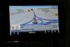
Not only are we getting new hardware, but there will be updated software to support it. The new software incorporates new junction graphics such as "Lane Separation" and "Complex Junction Details" similar to the Navigon Lane Assist launched a year ago, it also incorporates enhanced Voice Address Input, and possibly more important it now incorporates a new feature known as IQ routing.
IQ routing allows a route to be calculated based on recorded average speed information. This means that if a road is marked at 70MPH but the average speed on the road is actually 10MPH then the 10MPH figure will be used for routing calculations and the generated route may be a lot longer, but should be faster. This will no doubt be a much discussed feature in the forums as indeed the difference in route calculations always has been.
A quick scan through the features lists has the main differences between the units as the mapping (530 = regional, 730 = W/E Europe, 930 = USA, Canada, W/E Europe) and subsequent flash memory size. The 930 also features the Enhanced Positioning Technology as well as the Bluetooth remote control which is an optional extra in the 530/730.
The main new features of the (presumably V8) software are:
• Voice Address Input – Tell the GO where to go (TomTom Claim this is New but it's been available on the x20's for some time?)
• TomTom IQ Routes
– Intelligent routing based on real-world, historical average speeds
– Provides intelligent routing based on weekday and weekend averages
• Lane Separation
– Displays where to drive at complex multi lane junctions
– Enhances safety by avoiding last moment lane changes
• Complex Junction Details
– Complementing Lane Separation
– Displays detailed 3D image of complex junctions
– Maintains full visibility on the other essential details
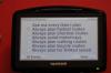
It also looks as though MapShare has been improved with the addition of 'Change Road Speed' on the first page implying that it will change your map straight away. This is purely speculation though based on how the MapShare menu's have functioned previously.
Update
Having got our hands on a GO 930 and having a chance to ask a few more questions about the new units and features we can now add the following information:
IQ Routing:
- Each road, on average, received about 1000 data submissions
- Over 500 million submissions were used to set up the IQ Routing engine
- The data is integrated into the maps
- It is NOT a plus service
- Data includes both the type of day (week day / weekend) and the time of day
- Route planning now adds an extra option of when you are travelling (today, tomorrow, week day, weekend)
- The feature can be disabled if required
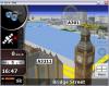
Lane Guidance:
- Mainly covers motorways but is obviously dependent on the map data available
- Static image is shown 'covering' the main screen and has flashing arrows. Distance to junction is still shown on screen
MapShare:
- Street restrictions editing interface has been improved
- Can now confirm that changes to road speed are now added instantly to your map
Click here to discuss...
|
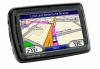
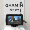
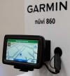
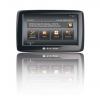
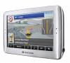
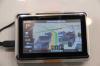
Garmin Launch New Nuvi Units at CeBIT - 2x5 series, 900T, 860 and 5000
Garmin have launched a handful of new nuvi devices across a wide price range and all use the new elevation-shaded base map.
The Nuvi 2x5 series is "the next evolution of the 200 series" and uses a new enhanced user-interface (UI) that not only always displays the current speed at all times but also has the 'next turn' information in the top corner as well as an enhanced Traffic screen. The 2x5 units also feature Garmin's HotFix technology which greatly improves GPS fix time. They can also make use of Garmin Connect Photo's - a collection of geo-tagged photo's that can be used for navigating to. They also use the new improved GTM-25 traffic receiver in which the aerial is integrated in the power-cable rather than as an external lead - you can add an external aerial if required still. They will be available from Q3 2008 with a range of mapping and screen sizes and prices will start form Ł139
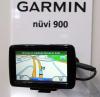
The Nuvi 900T will initially only be available in Italy and it's main selling point is the built-in DVB-H digital TV. The programmes are sent over the Three network and so far is only currently active in Italy (as they are testing in Hanover at the moment we were able to see the TV in action). It feature a 4.3" widescreen, Text-to-Speech directions, lifetime TMC subscription. The safety aspects of a TV in your sat nav are discussed here.
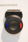
The Nuvi 860 is Garmin's flagship device for Europe. It is the European version of the 880 recently announced at CES in Las Vegas and features fully voice-controlled menus - It even worked with MaFt's Yorkshire accent! We will post a video soon of the menu's in action but to give a bit more information about how it works, not only can you go through the menus one by one (eg tools, media player) you can, from the main screen, say 'MP3 player' to jump directly to it or simply say 'find nearest Italian restaurant' and away you go! The 860 comes with a steering wheel controller with 2 buttons - on and off for speech recognition. It connects by bluetooth but as the 860 has a dual-channel bluetooth set up it means you can still have your phone connected for hands-free calling. Also new to the 860 are a handful of games (which need to be bought from www.garmin.com/games) and front-facing stereo speakers. It will be available around May for Ł499 with European mapping and a lifetime TMC subscription. Both the 900 and 860 feature user-changeable batteries.
And, finally, Garmin goes BIG with the 5.2" Nuvi 5000! “The nuvi 5000 is ideal for those with larger vehicles that need navigation on a big screen” and users can save upt to 10 routes with multiple via points. These routes can then be optimised to get the most efficient journey for multiple deliveries. You can also select areas on the map to avoid in the route. The Nuvi 5000 also features a video-input that can be used, for example, to show the feed from a reversing camera or DVD player. The 5000 also has a handful of games that can be bought from www.garmin.com/games and is expected to be available from May 2008 at Ł499.
|
Nav N Go Launch iGO MyWay 8 at CeBit
Hungarian software company Nav N Go have launched their newest software, iGo MyWay 8. This has been in the pipeline for some time now but has already featured in a handful of devices such as Sony’s Go! Explore for PSP and Mio’s C620 PND.
The new own brand version comes on a 2GB micro-SD card with adaptors for mini-SD and full size SD - the software is locked to the card so you cannot transfer it to a larger capacity card. It includes maps of both Western and Eastern Europe and features 43 languages.
The major selling point for iGO MyWay 8 is the 3D navigation which has been covered by PocketGPSWorld snce it was first announced last year. We will aim to review the full version in the very near future!
As per iGO 2006, UK distribution is being handled by Nemesis with further distributors in the pipeline. It retails at €149 (approx Ł110)
|
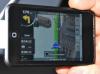
NavNGo To Release iGO for iPhone
NavNGo have developed a version of iGO MyWay 8 for the iPhone. It will use the upcoming iPhone GPS receiver and a demo video is available at YouTube. More details will be announced as soon as we have them!
|
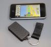
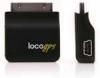
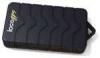
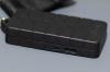
More Information on the gomite GPS Solution for iPhone (and any other WiFi enabled device)
There are 2 options for the iPhone GPS (gomite's locoGPS) - the future of one of these depends entirely on Apples SDK which is set to be released today!
Option 1 involves a GPS module that connects to the iPhone or iPod Touch itself and relies on Apple allowing such connectivity in their SDK (hopefully more news later today).
The other option, and one that will definitely be available in Summer 2008, is the locoGPS Wi-Fi GPS Mobile Navigation Server (MNS) - a wi-fi web-server that basically allows the iPhone (or any other wi-fi enabled device) to view it's web-page which will be where the GPS data is displayed - software can then parse this data to use in navigation software etc.
A specially developed version of Nav N Go's iGO 8 will be available as a separate product or as part of a package deal but further information will be released later.
|
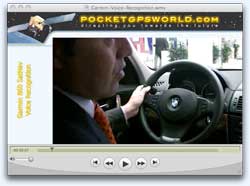
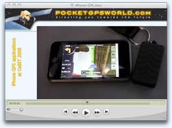
Videos of iPhone running iGO and Garmin voice recognition from CeBIT
  If a picture paints a thousand words then a video must represent a billion. But not only that it can give you a much better idea how things work than either plain words or static images. This year at CeBIT we captured 2 videos for you. If a picture paints a thousand words then a video must represent a billion. But not only that it can give you a much better idea how things work than either plain words or static images. This year at CeBIT we captured 2 videos for you.
The first is the proof that the new Garmin 860 SatNav voice recognition works directly from the the box with no voice training, and can even recognise different accents with no difficulty. Click here to view the Windows version of the Garmin voice recognition video, or click here for the Mac version of the Garmin voice recognition video.
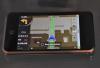
Our second video is a proof of concept demonstration of NavNGo iGO 8 software running on an Apple iPhone. The software will actually work on both the iPhone and the iPod Touch as they share the same underlying infrastructure. At the time these were proof of concept systems as Apple had not released the official iPhone SDK. As this has now been released the WiFi GPS solution will definately be certified, but the serial docking port GPS solution is still unclear. Click here to view the Windows version of the iPhone GPS video, or click here for the Mac version of the iPhone GPS video.
|
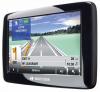
Navigon announce the Navigon 2100 max SatNav devices
Navigon announced a new range of SatNav systems at CeBIT today. Claiming to deliver high end functionality at mid range pricing USD $299. The press release and product details I have been given are for the US market, but I thought it useful to publish them in anticipation of getting the European version later.
The devices are 4.3 inch widescreen format with voice instruction delivered using text to speech. The software is the latest version of the Navigon software featuring Lane Assistance, Reality View and a new DirectHelp feature providing details of emergency facilities in your vicinity.
The Navigon 2100 Max has been launched with the new FreshMaps service which allows up to 12 map updates over a 3 year period.
Click here to read the full Navigon Press release and comment.
|
Navigon announce 3D terrain on the Navigon 8110 PND
When I was in Barcelona for the Mobile world Congress last month Navigon launched the 8110 PND as their flagship system. There were a number of features that they did not show me and disabled so I couldnt play with them.
Today I saw the full fledged system in the Navigon Press Conference, and the features were impressive...
Firstly there was a new version of the Lane Assistant which gives a heads up view of the lane you need to be in at a junction.
Then there was a new voice recognition system to allow you to speak the city street and house you want to navigate to.
But the most interesting visual display was the new 3D Terrain mapping.
|
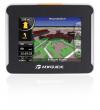
MyGuide Announce 2 New PND Lines (5 devices) at CeBIT
MyGuide have announced 5 new personal navigation devices spread across 2 lines: Exclusiv and Pure. All the devices will run a custom version of Nav n Go's iGO 8 software and features include: synchronise with Outlook contacts (navigate to your contacts' address), access to the MyGuide Life website (for up to date POIs, weather etc), text to speech guidance, 3D navigation (with road elevations, buildings etc), lane indication, speed cameras, speed limit warnings and a sleek 16mm thick design!
The premium Exclusiv Line is made up of the M.i.motion3318 (3.5"), M.i.motion4328 (4.3") and M.i.more4338 (4.3"). All the units have P3 player, in-built TMC and bluetooth for handsfree calling. The 4328 and 4338 also feature a video player. The 4338 is WiFi enabled and this can be used to connect to home networks, wifi hotspots etc to get up to the minute POI updates and software updates. You could, quite literally, walk into your home and the unit would log on to your network and update itself for you. All units feature Western European mapping and the 4338 also features Eastern Europe (i.e. full European mapping). The units will be priced from €199 (Ł159) to €349 (Ł279) and will be available from May 2008.
The entry-to-mid level Pure line consists of the M.i.move3218 (3.5") and M.i.move4228 (4.3"). These units are regional and will be available for European countries, North America, Australia, China and India. TMC is available as an optional extra. Prices are €129 (Ł103) for the 3218, €179 (Ł143) for the 4228 and will be available from mid-April.
|
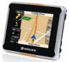
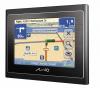
Mio-Navman / Navman-Mio Announce new Connected Devices - The First Devices to use SiRF InstantFix II
Putting the identity crisis to one side (is it Navman-Mio or Mio-Navman?!) Navman-Mio are making some major changes. The whole company is being rebranded and new devices are being launched. In the UK, Spain, Australia and New Zealand the devices will continue to be marketed under the Navman name and as Mio everywhere else. This will no doubt change over time.
The new units form the Mio Moov range and are the first in Europe to feature dynamic local POI searches (via bluetooth connection to a GPRS-enabled phone). The live searches can also be performed via the new MioMore desktop software. They are also the first devices to feature the new SiRF InstantFixII technology - the fasted GPS connection! The new devices use TeleAtlas maps with 3D building data and now use Navman's routing software.
The entry-level Moov 200 (Europe or Regional) feature Local search via MioMore desktop software, trip meter and 3.5" touch screen. The 330 Regional and 330 Europe also feature 4.3" wide screen, local search via bluetooth, NavPix photo navigation and mileage reporter. The 370 Europe features, on top of those already mentioned, built-in TMC.
The Navman 'equivalent' of the Mio Moov 330 is the S50 3D - an updated version of the S50 featuring the 3D mapping and local search etc. The Navman S30 3D is essentially the same as the Mio Moov 200 Regional.The updated desktop software is called Navman Connect as opposed to MioMore.
Available in April 2008, the prices are as follows:
Mio Moov 370 Europe - €279 (Ł223)
Mio Moov 330 Europe - €229 (Ł183) / Navman S50 3D - Ł179
Mio Moov 330 Regional - €179 (Ł143)
Mio Moov 200 Europe - €179 (Ł143)
Mio Moov 200 Regional - €149 (Ł119) / Navman S30 3D - Ł129
|
Nav N Go announce strategic partnership with QNX to provide better faster 3D graphics.
Nav N Go are well known for the innovative implementation of the 3D mapping solution iGO8. Although we saw the embryonic iGO8 at CeBIT last year it has yet to be released on the PDA standalone platform. However a number of OEM partners including Mio have released it.
We were most impressed with the implementation we were shown last year Nav N Go did an excellent job of optimising the mapping and graphics to allow iGO8 to run on SmartPhones and PNDs. 3D graphics are a heavy consumer of resources for a small system and this is where the strategic partnership with QNX comes in. QNX specialise in creating operating systems for realtime embedded hardware. This means that the system can be optimised for fast high end graphics processors enabling faster smoother rendering of 3D images.
Click here to read the press release and discuss...
|
Amaryllo and SiRF announce partnership for dynamic traffic and content reception solutions
Dutch navigation products developer Amaryllo and US based SiRF Technology today announced a partnership to support and promote Amaryllo's Dynamics platform.
Dynamics is a traffic- and content reception solution geared towards PNDs, navigation systems and smart phone manufacturers. It will be promoted as an optional feature of the Centrality and other SiRF GPS chipsets.
Dynamics enables hardware developers to integrate dynamic content into their products and provides transparent access to various broadcast based information services such as traffic and weather information. This information then can be used in navigation systems, mobile phones, handheld devices, multi-media players and GPS devices to offer rich and real time content to the user. It allows navigation hardware and applications to receive RDS/TMC data using a generic API supporting many different hardware options. The system will be expanded to fully integrate RDS/TMC, MSN Direct, DARC, OpenTMC, DAB, DVB-H, XM, RT, RT+, NOAA and other data broadcast formats into one unified modular platform API. Amaryllo Dynamics is available in several configurations and supports both external MCU or direct integration in the navigation chipset. The system supports Silabs and NXP FM tuner chips.
The SiRF/Amaryllo combination is currently available and shipping with more than a dozen manufacturers of PND devices currently designing Amaryllo Dynamics into their devices. A first device is already in mass production and available on the European market.
www.amaryllo.com
|
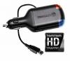
TomTom announce new HD Traffic at CeBIT
Well it looks like BluRay has won the format war for HD in the DVD arena, now TomTom wades into the marketplace with HD Traffic.
TomTom HD traffic is basically a replacement power cable which not only powers the SatNav but also has built in communications capabilities (using a SIM card and GPRS) to provide real time traffic information. This data is not just the standard traffic data we get via TMC, but it is enriched with actual current traffic conditions (via anonymous cellphone monitoring) enabling better and more accurate routes to be generated with realistic Estimated Times of Arrival.
Currently HD Traffic will be available on the new GO x30 range and the current GO x20 for €60 including 6 months subscription. Other devices will follow later with a software upgrade.
Click here to discuss...
|
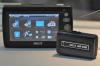
Royaltek show Speed Camera warning systems at CeBIT
RoyalTek had two speed camera warning systems at the CeBIT expo. Both systems were pre-production, but were able to show the unit's functionality.
Of the two models one is a simple warning system issuing a beep when approaching a camera. The other is a more sophisticated "all singing, all dancing" model. This features a heads up display on the windscreen including differentiation of the different cameras, speed warnings and a directional indicator showing where the camera is.
|
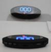
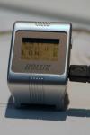
Holux Announce 2 New GPS Trackers - GR-510 GPS Tracker and GR-530 GPS Wrist Tracker
Holux have announced 2 GPS tracking devices that use aGPS for positioning and SMS to send out it's co-ordinates. Both devices feature an SOS button and can be tracked via a mobile phone or via a specific Holux tracking web site.
They can be configured, activated and deactivated via SMS messages and are waterproof (IPX-6). The logs can also be downloaded to a PC to be checked at a later date. The GR-530 is a 'wrist-watch' so would be ideal for tracking children or elderly.
Grace Ho of Holux referred to the GR-510 as a "Husband Tracker". I was a little shocked at this concept, it would be the cause of a lot of divorces... "I am sorry dear I am stuck in traffic..." would no longer work when the tracker clearly shows that you have stopped in the local bar for a quick drink. On a more practical side a more useful function concept was show. If you have a Holux PND it will be possible to show the location of the "Husband Tracker" and navigate to it. Yet another dangerous idea :D
|
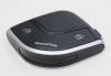
Qstarz showcase new goetagging dataloggers and sports GPS systems
Qstarz are not in the main SatNav halls this year. In fact they were just about as far away as you could possibly get. Diagonally across the fairground. This was the only time I actually managed to get to see anything outside the navigation halls.
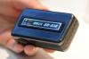
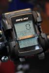
As usual Qstarz had a number of new and future products on display. Starting with the BT-Q1000 Platinum GPS Travel Recorder. This is an upgraded version of the BT-Q1000 we reviewed last year, with the ability to record 200,000 datapoints and new software to Geotag photos and integrate with Google Earth.
There is the PR-Q1100, another GPS Datalogger, this time with a small LCD information panel. This features an MTK GPS chipset and software to tag digital photos and integrate to Google Earth.
A new area for Qstarz is the fitness market, and on display is the BT-Q2000, a waterproof system powered by a SirfStarIII chipset. The software implements a GPS trip/activity computer for your bike or maybe running sports activities. It is also a datalogger with the ability to record up to 130,000 trackpoints.
|
Wonde Proud Display 2 GPS Trackers at CeBIT - VT10 and SPT10
Taiwanese company, Wonde Proud, were displaying 2 GPS tracking devices - the VT10 vehical tracker and SPT10 personal tracker.
Both devices will log over 100,000 locations, feature geo-fencing control, are quadband (GSM 850 / 900 / 1800 / 1900), use a 20 channel GPS receiver, feature an emergancy alert and have 4mb of flash memory. The VT10 also has a mileage report and speeding alert where as the SPT10 has a movement alert function.
|
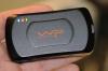
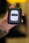
Globalsat display iPhone GPS concept
In anticipation of today's iPhone SDK announcement from Apple, Globalsat had on display a concept GPS device that attaches to the iPhone's dataport.
On the assumption that Apple will allow access to external serial devices this GPS will work well. and is based on the SiRFStarIII ultra-low power chipset.
Of course it will rely on the availability of GPS applications becoming available for the iPhone but early indications are that developers are queuing up in anticipation.
|
Authorities raid CeBIT exhibitors for Patent and License infringements.
Each year we visit CeBIT and we see Police and Customs officials paying visits to some of the exhibitors to serve writs over Patent, Copyright, and License infringements.
Last year we followed Harald Richter as he examined the mounts displayed in some of his competitor's and other exhibitors discovering a huge number of illegal copies of his patent designs. He applied to a magistrate and had a number of these items removed with papers served for the offenders to appear in court.
This year over 50 exhibitors had writs served and were visited by the authorities most having large numbers of devices seized. Now in the majority of cases this was fully justified. You would not believe the sheer number of iPhone and iPod copies... However I spoke to a couple of companies who had been shut down over the alleged MP3 license infringements, they fully believed that they had properly licensed their systems and were being unfairly targeted.
I can see both sides of the argument, particularly in the case of HR a small company fighting to enforce its patents, but where there is significant doubt as in the case of one of the companies I spoke to it seems exceptionally unfair not only to deprive them of the business they can garner from the show, but also to taint their reputation as well. I have deliberately not mentioned any names here to prevent further damage to the company's reputation.
|
ONeill and MyGuide collaborate to create the NavJacket
Hi Tech wearable clothing has just jumped a few generations on the evolution ladder with the introduction of the O'Neill Nav Jacket.
The 'H' division of MyGuide (I think that should really have been the Q division) have developed a Hi Tech Gortex waterproof jacket with an integrated GPS. James Bond gadgets have now become a reality. The Jacket has a display panel on the lower left sleeve whilst the controls are located on the upper left sleeve. This display will guide you to your selected destination.
In case you are too busy trying to stay alive bombing down the ski slope dodging bullets from Blofeld's evil henchmen, then you have spoken direction instruction from the audio interface located in the hood.
If you are in an area of mobile phone coverage then you can also locate Miss Moneypenny using the built in friend finder feature, or maybe follow the trail of 006 as he wends his way down the slopes...
The Jacket is currently undergoing real life testing in the winter season in the Alps, and will be available as part of the O'Neill 2008/2009 Autumn/Winter collection.
|
Anyone need a condom?
As I was traversing between two halls the other day I had to go through a hall full of mobile phones... Not a big problem, but as I was near the exit I encountered a huge crowd around one particular stand called Skinz. I had not option but to push through the crowd to get to my next meeting. Curiosity overcame me and I had to find out what was going on. As I approached the front of the stand I saw 2 girls wearing bikinis in a hot tub!!!
I thought this a bit of a strange gimmick to sell phone accessories, but I didnt object too much as the girls were cute. As I went past them I was stopped and presented with what looked to me like a condom!!
Now I know that a certain member of the PocketGPSWorld.com team often uses condoms to protect his valuable equipment (of the electrical variety) when he is hiking in the USA so I was familiar with the concepts. The idea is that you unroll it over your phone and it is protected from rain, snow or even paint (if you decorate). It looks like it will work well. The girls had their phones underwater, and you could still read the screen through the latex.
Interestingly just before I was about to leave to return home I was talking to Jimmy Huang President of Evermore Technology and told him about the "condoms". He was most interested and so I led him to the booth where they demoed the protection by encasing one of the Evermore GPS Dataloggers Jimmy was carrying and throwing it in the hot tub. In future you may find Evermore GPS devices being supplied with condoms...
|
|
|
|
References |
|
| Manufacturers Website |
|
| Pocket GPS Contributor |
Mike Barrett, Maft |
| Pocket GPS Contributor Website |
www.Pocketgpsworld.com |
| |
|
|
|
|
 |
 |
 |
 |
|
|