|
|
 |
 |
 |
 |
Just How Much Has OSM Grown Go See For Yourself
Article by: maft
Date: 11 Aug 2014
In 2007 the OpenStreetMap project had close to 10,000 members, held their first 'State of The Map' conference, had around 100 million GPS points and held their 3 year anniversary party in London. The coverage was, to be fair, pretty poor.
Jump ahead 7 years to 2014 and there are well over a million registered users, over 20 million edits and far, far better coverage around the world.
But just how much has it improved?
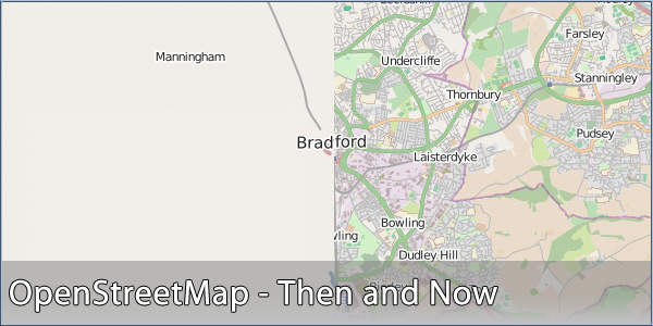
I've personally been adding data to OpenStreetMap since late 2007; driving around the streets of Bradford with a GPS Datalogger placed on my dashboard, importing the tracks to the (then clunky) website in order to draw the roads on there and, when I remembered, also adding the street names. As time went on and smartphones were becoming more mainstream, so too did the apps available that could both use OSM data as well as log and submit new data.
I even went as far as adding local playing fields, public footpaths and some POIs. These were particularly useful for using the GeoCaching app, which can use OSM data, as the footpaths needed for many rural caches were simply not available on 'official' mapping.
As such, the quality and coverage has vastly improved and a Dutch developer, Martijn van Exel, has created a nifty little website that allows you to easily compare the current and 2007 datasets to see for yourself.
Head over to http://mvexel.github.io/thenandnow/ to see for yourself. Locate your area of interest and then use the slider at the top to adjust how much you see of 2007 and 2014. I think, like me, you will be quite impressed!
| | |  |
| Comments
|
 Posted by Privateer on Wed Aug 13, 2014 11:52 am Posted by Privateer on Wed Aug 13, 2014 11:52 am |
 |
I had a look at the Oxford area. Although even in 2007 a lot of roads in the surrounding area existed on the OSM maps, the increase in detail of the map in 2014 is much greater and impressive.
| MaFt Wrote: | | I've personally been adding data to OpenStreetMap since late 2007; driving around the streets of Bradford with a GPS Datalogger placed on my dashboard, importing the tracks to the (then clunky) website in order to draw the roads on there and, when I remembered, also adding the street names. As time went on and smartphones were becoming more mainstream, so too did the apps available that could both use OSM data as well as log and submit new data. |
What app(s) would you recommend, for iPhone, that can both use as well as log and submit new data to OSM? Preferable Apps that you can use abroad via WiFi and not data roaming.
How long does it take for an update to be become accepted and part of the data?
What are the best SatNav iPhone apps that use OSM data that is available straight from OSM? I.e. is you submit an update you want to use it in the SatNav app as soon as possible,
| MaFt Wrote: | | I even went as far as adding local playing fields, public footpaths and some POIs. These were particularly useful for using the GeoCaching app, which can use OSM data, as the footpaths needed for many rural caches were simply not available on 'official' mapping. |
Presumably the geocaching apps are the ones by Groundspeak?
Robert.
iPhone 6s Plus, iOS 14.0.1: iOS CamerAlert v2.0.7
TomTom GO Mobile iOS 2.3.1; TomTom (UK & ROI and Europe) iOS apps v1.29
Garmin Camper 770 LMT-D |
|
| Posted by alan_sh on Wed Aug 13, 2014 1:59 pm |
|
Impressive. But don't try it with IE11 - you just get a big white screen. Firefox works fine.
Alan
|
|
| Posted by sussamb on Wed Aug 13, 2014 2:10 pm |
|
Working fine with IE11 on my PC, you must have something blocking it.
Where there's a will ... there's a way. |
|
| Posted by MaFt on Wed Aug 13, 2014 6:44 pm |
|
Privateer:
Motion X GPS is the app I used for logging new routes. I can't remember if I uploaded them directly to OSM through there or if I emailed them to myself to upload.
The OSM maps are usually updated on a daily basis but depending on the app, whether they use the data directly or use image/map tiles, can make a difference to how quick the user gets them.
|
|
| Posted by DennisN on Thu Aug 14, 2014 7:27 am |
|
Interesting. I have found that TomTom for iPhone does not include Greece in Europe (!), so I saved myself from buying it. So is there a navigation app which uses OSM downloaded onto the iPhone so it doesn't need roaming? I'm going to the island of Skiathos in four weeks and it's quite a small place (12 x 5km) so downloaded and saved tiles (?) wouldn't take much. We'll only hire a car for one or at most two days and you can tour the island easily in that time. I see the OSM map for it is every bit as good as the existing paper maps - I might as well get lost with OSM as with the paper map and chances are it will save me driving in and out of back gardens on the unsurfaced tracks.
Dennis
If it tastes good - it's fattening.
Two of them are obesiting!! |
|
| Posted by Privateer on Thu Aug 14, 2014 11:20 am |
|
| MaFt Wrote: | Privateer:
Motion X GPS is the app I used for logging new routes. I can't remember if I uploaded them directly to OSM through there or if I emailed them to myself to upload.
The OSM maps are usually updated on a daily basis but depending on the app, whether they use the data directly or use image/map tiles, can make a difference to how quick the user gets them. |
Many thanks for that MaFt, I'll have a look.
Regards,
Robert.
iPhone 6s Plus, iOS 14.0.1: iOS CamerAlert v2.0.7
TomTom GO Mobile iOS 2.3.1; TomTom (UK & ROI and Europe) iOS apps v1.29
Garmin Camper 770 LMT-D |
|
| Posted by Privateer on Thu Aug 14, 2014 11:42 am |
|
| DennisN Wrote: | | So is there a navigation app which uses OSM downloaded onto the iPhone so it doesn't need roaming? |
Hi Dennis,
Have a read of the PGPSW article "Telenav choose OpenStreetMap data for Scout app"
Scout for iPhone, Android
http://www.telenav.com/products/scout/
However Scout is not available for UK iTunes, so you could try "GPS Navigation by Scout (Sat Nav)" by skobbler GmbH), which is allegedly the same as Scout although as they have called it something else it does make me wonder. Have a look at:
https://itunes.apple.com/gb/app/gps-navigation-by-scout-sat/id329340711?mt=8
I've not used GPS Navigation by Scout (Sat Nav) on my iPhone but Bo Peep has. I've had a little try with it and then bought TomTom UK as that covered everything that I needed.
GPS Navigation by Scout costs 69 pence, but that only covers you for the UK. You have to use in app purchasing for additional countries. I think that Ł7.00 or so gives you access to all of the world - or at least all available OSM maps. For the few minutes that I tried it it was OK however I haven't done a full journey in it. I don't know it it does third party POIs but I guess if you are able to update OSM yourself then you can probably add the POIs to OSM and then reload the map.
Let us know what you think to it if you try it.
Regards,
Robert.
iPhone 6s Plus, iOS 14.0.1: iOS CamerAlert v2.0.7
TomTom GO Mobile iOS 2.3.1; TomTom (UK & ROI and Europe) iOS apps v1.29
Garmin Camper 770 LMT-D |
|
| Posted by Kritou on Thu Aug 14, 2014 12:09 pm |
|
Put PocketEarth on your iPhone - you will be delighted
As well as driving it offers routeing for cyclists and hikers
καλό ταξίδι
|
|
| Posted by rkm_hm on Fri Aug 15, 2014 10:38 am |
|
| alan_sh Wrote: | Impressive. But don't try it with IE11 - you just get a big white screen. Firefox works fine.
Alan |
That's interesting! Firefox doesn't work on my computer. It displays the 2014 version of the map ok, but there's no slider for looking at the 2007 version.
However, Chrome works fine - complete with slider!
I can only assume that it uses some particular feature which may or may not be present depending on how your browser is set up.
Roger
TomTom via135
Satmap Active 10+ v1.50 with full UK 1:50k map and 1:25k/1:10k County maps of Hampshire & Warwickshire |
|
| Posted by DennisN on Fri Aug 15, 2014 12:31 pm |
|
| Kritou Wrote: | Put PocketEarth on your iPhone - you will be delighted
As well as driving it offers routeing for cyclists and hikers
καλό ταξίδι |
Efxaristo, but I've already got that and it has poor coverage of Skiathos, not as good as OSM.
Dennis
If it tastes good - it's fattening.
Two of them are obesiting!! |
|
| Posted by K13ehr on Sat Aug 16, 2014 9:58 am |
|
Thanks to Maft and others who have put the time and effort into this task, I only heard of it a little while ago, but now use Maps.me extensively and the info is second to none, I hope it too become a sat nav one day.
|
|
|
| Click here to view more comments... |
|
 |
|
|
 |
 |
 |
 |
|
|


